| |
|
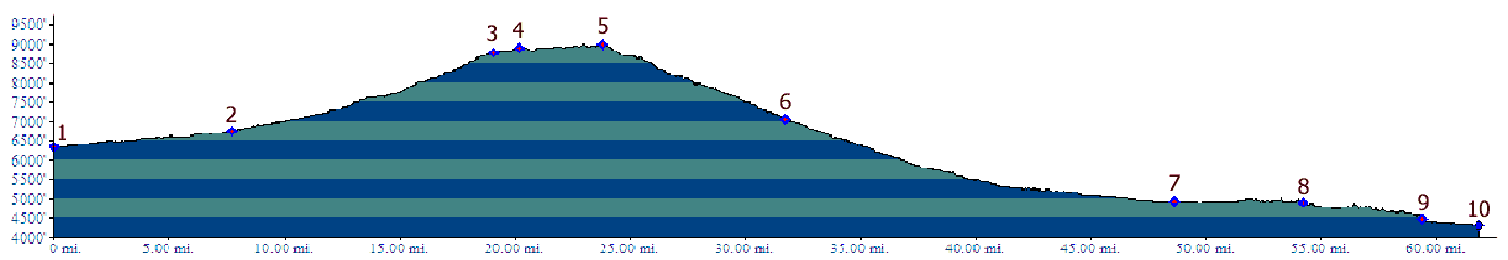
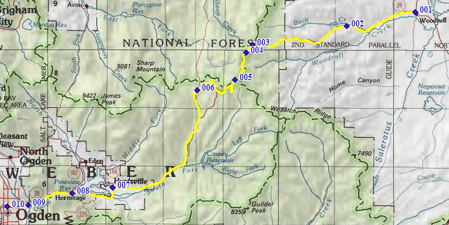
01.(6340ft,mile00) START-END EAST: jct
Ut16 - Ut39 in Woodruff
02.(6740ft,mile08) START-END EAST ALTERNATE: turnoff to
Birch Creek Reservoir on right
03.(8770ft,mile19) FR59 on right leads down to Randolph
04.(8890ft,mile21) Monte Cristo campground and ranger
station
05.(9010ft,mile25) TOP: on north west flank of Monte
Cristo Peak
06.(7060ft,mile32) turnoff on right goes to Hardware
Ranch
07.(4920ft,mile49) START- END WEST: Ut39 turns left,
east of Huntsville. Profile continues down Ogden Canyon,
since this is the most direct approach. For a less
dangerous route turn right towards North Ogden Canyon.
08.(4910ft,mile55) turning right onto Ut162 also leads
to North Ogden Pass. Profile continues straight down
Ogden Canyon
09.(4470ft,mile60) Route leaves North Ogden Canyon and
continues on bike path on Ogden River.
10.(4310ft,mile62) START-END WEST ALTERNATE: jct bike
path - Washington Ave in Ogden.