| |
|
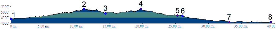
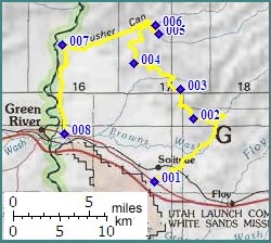
1.(4380ft,mile00) START-END EAST:
unmarked dirt road turnoff on US6
2.(5290ft,mile12) intermediate high point
3.(4880ft,mile15) intermediate low point
4.(5300ft,mile20) TOP: point of highest altitude
5.(4700ft,mile26) jct with right hand Tusher Canyon road. Profile continues left
6.(4690ft,mile27) jct with left hand Tusher Canyon road. Profile continues left
7.(4100ft,mile34) START-END WEST ALTERNATE: Tusher Canyon road joins paved road along Green River
8.(4120ft,mile40) START-END WEST: jct: road along Green River, US6