| |
|
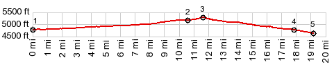
1.START-END WEST:low point on Tule Valley
Rd
2.profile turns left onto Steamboat Pass Rd
3.TOP: Steamboat Pass,5280ft
4.profile leaves Steamboat Pass Rd, on order to find a
low point on this side
5.START-END EAST:Black Hills Well
|