| |
|
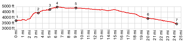
1.(00.0m,3700ft) START-END EAST: Grafton
Rd crosses Virgin River in Rockville
2.(03,4m,438ft)jct with Wire Mesa out and back road
3.(05.1m,4700ft)jct with Grafton Mesa out and back road
4.(06.3m,4920ft)TOP: jct with road to Gooseberry mesa
5.(09.1m,4840ft)profile turns left onto Ut59
6.(20.0m,3940ft)profile turns right onto Sheep Bridge Rd
7.(24.3m,3470ft) START-END WEST: low point on Sheep
Bridge Rd, immediately before meeting Ut9
|