| |
|
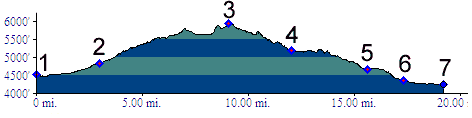
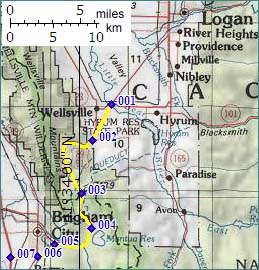
1.(4510ft,mile00) START-END NORTH: jct Ut101-US89, east of Wellsville
2.(4840ft,mile03) START-END NORTH ALTERNATE: jct US89-paved road from Hyrum
3.(5868ft,mile09) TOP: Sardine Summit
4.(5190ft,mile12) northen turnoff to Mantua
5.(4670ft,mile16) START-END SOUTH ALTERNATE: jct US89-Ut90 to downtown Brigham City. Profile continues along US89
6.(4350ft,mile18) jct US89-US91; profile continues straight to I25
7.(4240ft,mile19) START-END SOUTH: jct I25- Ut91