| |
|
La Salle Loop road summit(u) via Sandflats Road - (partially unpaved)
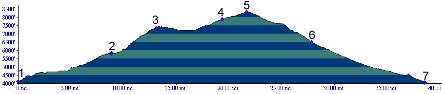
01.(4130ft,mile00) START-END WEST: turnoff to Sandflats road, south of Moab
02.(5840ft,mile09) Kokopelli Trail, here also called Porcupine Rim Trail leaves Sandlfats Road on left. But profile continues straight on Sandflats road.
03.(7362ft,mile18) trail on left leads to Porcupine Rim. Profile continues right.
04.(7880ft,mile)20 Sandlfats road joins paved La Sal Loop road. Continue left.
05.(8320ft,mile22) TOP: high point on La Sal Loop road, Kokopelli Trail summit(u):m124
06.(6490ft,mile28) La Sal Loop road joins road to Castleton. Kokopelli Trail goes back uphill to right, while profile continues down valley to Castleton.
07.(4060ft,mile38) START-END EAST: junction Ut128 and road to Castleton
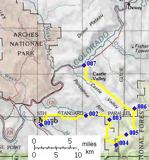
La Salle Loop road summit via principal
paved approaches

1.(4860ft,mile00) START-END SOUTH: southern end of La Sal
Loop Road, near Ken;s Lake, south of Moab
2.(5710ft,mile07) road up Pack Creek diverts on right
3.(7970ft,mile12) intermediate high point, just after
turnoff to Geyser Pass
4.(7740ft,mile14) road on right goes to Ooowah Lake, dirt
5.(7940ft,mile15) road on right goes to Warner Lake
campground
6.(7880ft,mile18) Sandflat Road joins La Sal Loop road
from right
7.(8320ft,mile20) TOP: high point on La Sal Loop road,
Kokopelli Trail summit(u):m124
8.(6490ft,mile26) La Sal Loop road joins road to
Castleton. Kokopelli Trail goes back uphill to right,
while profile continues down valley to Castleton.
9.(4060ft,mile36) START-END NORTH: junction Ut128 and road
to Castleton
