| |
|
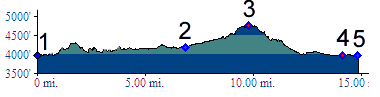
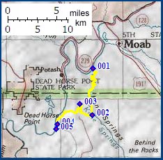
1.(3980ft,mile00) START-END NORTH: road leaves Colorado River south of King's bottom.
2.(4190ft,mile07) junction with trail up Cane Creek
3.(4780ft,mile10) TOP: Hurrah Pass
4.(3980ft,mile14) junction with double track trail on left
5.(3870ft,mile15) START-END SOUTH: low point where road crosses a wash