|
|
|
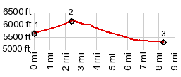
1.START-END WEST: King's Wells Rd crosses
a dry stream bed, after first summit from jct with
Asphalt Wash
2.TOP,6230ft
3.START-END EAST: intermediate low point on road at
5320ft
|