| |
|

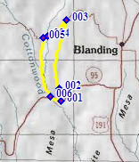
1.(5190ft,mile00) START-END SOUTH-EAST: Jeke's Hole, low point on Ut95, south of Blanding, also the junction to CR227
2.(5600ft,mile02) CR227 stays left at this fork
3.(6410ft,mile07) TOP: CR227 Brush Basin Rim Rd terminates onto CR228. Profile turns left
4.(5510ft,mile10) intermediate low point
5.(5710ft,mile11) profile stays left to descend on CR268 along Cottonwood Creek
6.(5220ft,mile16) profile turns left onto Ut95
7.(5190ft,mile17) START-END SOUTH-WEST: same as point 1