| |
|

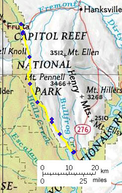
01.(mile00,4990ft) START-END NORTH: junction between Notom rd and Ut24
02.(mile04,5200ft) junction with cutoff to Ut24 direction Hanksville on left
03.(mile04,5240ft) junction with dirtroad to Notom on right
04.(mile14,5290ft) dirt road into Henry Mtns is on left
05.(mile25,5710ft) TOP: Bitter Creek Divide
06.(mile33,5000ft) Burr Trail branches off on right
07.(mile44,5040ft) surface is paved from here, jct with Clay Point rd.
08.(mile45,4960ft) first turnoff to Hall Creek Canyon overlook
09.(mile51,5080ft) second turnoff to Hall Creek Canyon overlook
10.(mile60,3770ft) START-END SOUTH: Bullfrog Bay campground turnoff
11.(mile61,3700ft) START-END SOUTH ALTERNATE: Bullfrog Bay campground