| |
|
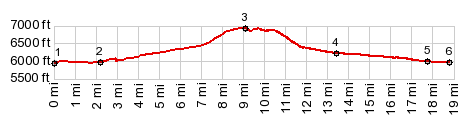
1.(00.0m,5930ft)START-END SOUTH: low point on Cisco Rd on shore of Bear Lake
2.(02.2m,5970ft)profile turns up South Eden Canyon
3,(09.0m,6960ft)TOP; also jct with more heavily used route on left going up Black Mountain
4.(13.4m,6420ft)route turns down North Eden Canyon on indistinct track
5.(17.8m,5990ft)profile rejoins Cisco Rd
6.(18.6m,5950ft)START-ENDN NORTH: low point on Cisco Rd, just inside Idaho
|