| |
|
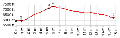
1.(00.0m,5940ft)START-END WEST: north end of Main Street in Laketown, along shore of Bear Lake
2.(00.9m,5960ft)route joins Ut30, south side of Bear lake
3.(05.4m,7090ft)route turns off Ut30 onto unmarked dirt road
4.(06.3m,7290ft)TOP
5.(15.7m,6240ft)START-END EAST: profile joins paved Manhead Rd
|