|
-
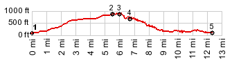
1.(190ft,mile00.0)START-END WEST: Dabney State Rec Area, Troutdale
2.(860ft,mile05.5)Chanticlear Point overlook
3.(900ft,mile06.0)TOP: jct with East Larch Mtn Rd on right
4.(660ft,mile06.8)Vista House
5.(110ft,mile12.6)START-END EAST: low point on historical US30, just west of I84 Bridal Veil exit
View Or_us30_hist_chanticlear_point_sh.gpx in a larger map |
-