|
-
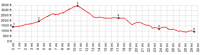
1.(1450ft,mile00.0)START-END SOUTH-1: jct US26 - East Lolo Pass Rd
2.(1990ft,mile04.2)profile stays left at fork with Muddy Fork Rd
3.(3460ft,mile10.5)TOP: Lolo Pass
4.(2300ft,mile17.1)START-END NORTH ALT: jct with FR16 Vista Ridge Road on right
5.(1240ft,mile23.7)jct with Lost Lake Rd on right
6.(990ft,mile29.3)START-END NORTH: jct Green Point Rd - Or281
View Or_lolo_pass in a larger map |
-