|
-
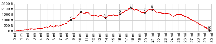
01.(20ft,mile00.0)START-END SOUTH: jct US101 - FR57 Big Creek Rd
02.(1130ft,mile08.5)FR57 Big Creek Road ends onto paved FR58
03.(1780ft,mile10.2)intermediate top on FR58
04.(1240ft,mile13.9)intermediate low point, immediately after jct with FR5130
05.(1560ft,mile16.1)profile stays left at jct with FR3700
06.(2160ft,mile17.7)TOP
07.(1760ft,mile19.9)intermediate low point
08.(2080ft,mile21.1)intermediate top on FR55 Cummins Peak Rd
09.(130ft,mile29.9)FR55 Cummins Peak Rd terminates onto US101
10.(110ft,mile29.9)START-END NORTH)low point on US101, just north of Cape Perpetua visitor center
View Or_fr58_klickitat_rd_u in a larger map |
-