|
-
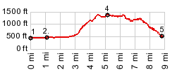
1.(440ft,mile00.0)START-END WEST: jct Loon Lakr Rd - Soup Creek Rd, north of Ash
2.(480ft,mile01.1)route gros right onto Soup Creek Rd.
3.(1410ft,mile04.4)TOP: immediately beore turning right onto Buck Creek Rd
4.(1400ft,mile05.2)profile stays left on Lindy Bridge Rd
5.(580ft,mile08.9)START-END EAST: jct Camp Creek Rd - Lindy Bridge Rd
View Or_buck_creek_via_soup_creek in a larger map |
-