|
-
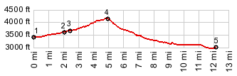
1.(3440ft,mile00.0)START-END WEST: low point on US26
2.(3640ft,mile02.0)jct with US26 to Government Camp on left
3.(3700ft,mile02.5)profile turns right onto small paved sideroad
4.(4155ft,mile05.0)TOP: Barlow Pass
5.(3080ft,mile12.1)START-END EAST: jct Balow Pass Rd - FR48
View Or_barlow in a larger map |
-