|
|
|
-
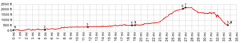
1.(60ft,mile00.0)START-END WEST: jct Or38-Loon Lake Rd
2.(230ft,mile05.00)route turns left onto Camp Creek Rd
3.(390ft,mile11.6)jct with Buck Creek Rd on lef
4.(570ft,mile18.7)jct Camp Creek Rd - Lindy Bridge Rd - Little Camp Creek Rd
5.(620ft,mile19.2)jct with BLM 23-8-36.1 (google maps designation) road on left
6.(2100ft,mile26.7)confusing ridge top intersection: Camp Creek Rd - BLM25-7-5.1 and others; profile goes left
7.(2260ft,mile27.0)TOP
8.(620ft,mile33.4)START-END EAST: same as point 5
View Or_blm_25-8-28 in a larger map |
-