| |
|
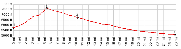
1.(5789ft,mile00.0) START-END WEST:
jct US50 - CR38 Osceola Rd
2.(7640ft,mile05.4) TOP
3.(6810ft,mile10.3) START-END EAST: CR38 ends on US50 and profile
continues to right
4.(5100ft,mile25.8)START-END EAST ALT: jct Ut159 - US50, just east
of Ut-Nv line
| |
![]()