| |
|
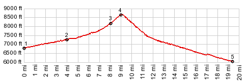
1.(6800ft,mile00.0) START-END WEST: NV486 crosses Steptoe Creek
2.(7280ft,mile04.0) profile turns left onto FR50574
3.(8250ft,mile08.1) profile stays left on FR50436
4.(8640ft,mile09.1) TOP
5.(6040ft,mile19.4) START-END WEST: jct NV893
|
![]()
|
1.(6800ft,mile00.0) START-END WEST: NV486 crosses Steptoe Creek 2.(7280ft,mile04.0) profile turns left onto FR50574 3.(8250ft,mile08.1) profile stays left on FR50436 4.(8640ft,mile09.1) TOP 5.(6040ft,mile19.4) START-END WEST: jct NV893
|