| |
|
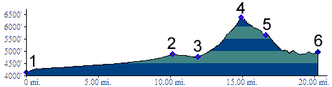
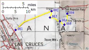
1.(4130ft,mile00) START-END EAST ALTERNATE: first I70 service road access, east of junction with I25
2.(4880ft,mile11) go right off I25
3.(4780ft,mile12) START-END EAST: Baylor Pass trailhead; profile between here and point 5 is aproximate.
4.(6350ft,mile15) Baylor Pass
5.(5670ft,mile17) pick up paved Aguirre Springs road.
6.(4870ft,mile21) START-END WEST ALTERNATE: junction with road to White Sands, continue straight for San Augustin Pass