|
|
|
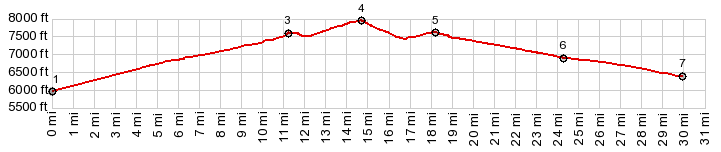
1.START-END EAST-1:jct Doublesprings Rd -
FR118, west of Goldburg
2.jct Donkey Hills Rd - Doublesprings Rd
3.profile turns left onot FR117
4.TOP,7960ft: Horseheaven Pass
5,profile turns left following unmarked road along
Mahagony Creek and after that Pahsimeroi River
6.profile turns left onto Donkey Hills Rd
7.START-END EAST-2: low point, just before reaching
point 2
|