| |
|
|
|
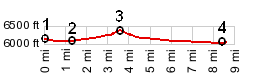
1.(00.0km~0.0mi, 1853m~6079ft) START-END
EAST: jct Wy89 - US30 south of Geneva, Id
3.(02.4km~1.3mi, 1847m~6060ft) low point
2.(05.7km~3.5mi, 1938m~6325ft) TOP: Border Summit
3.(13.7km~8.5mi, 1832m~6010ft) START-END WEST: route
reaches Sheep Creek, south west of Geneva
View id_Border_Summit in a larger map |