|
|
|
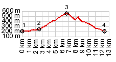
1.(00.0km,190m)START-END WEST:low point
next to river la Baume, Pont en Royans
2.(02.6km240,m)profile turns away from D531 and climbs
out of Gorge de la Bourne
3.(06.9km,560m)TOP: Col de Toutes Aures
4.(12.6km,190m)START-END EAST: low point near river in
Pont en Royans
|