| |
|
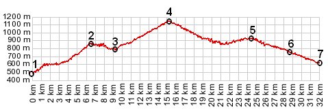
1.(00.0km,477m) START-END NORTH ALT: Entrevaux
2.(06.5km,852m) intermediate high point
3.(9.2km,798m) START-END NORTH: four roads meet near this low point at a stone bridge. Profile continues straight on D710
4.(15.2km,1147m) TOP: Col de Trebuches
5.(24.3km,880m) la Rochette
6.(28.7km,745m) Saint Pierre
7.(31.9km,621m) START-END SOUTH: jct D10- D2211, along Vallon des Miolans
|