| |
|
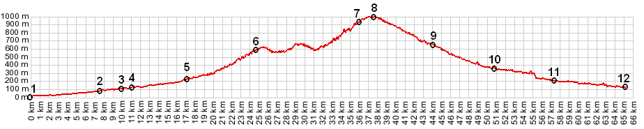
01.(00.0km,6m) START-END SOUTH ALT: port in Nice
02.(07.6km,74m) la Trinite
03.(09.6km,97m) Cantaron
04.(10.9km,105m) START-END SOUTH: jct D21-D2104, north of Cantaron
05.(17.0km,225m) Contes
06.(24.5km,592m) Coroaze
07.(36.1km,972m) Col du Savel
08.(37.7km,990m) TOP: Col Saint Roche
09.(44.0km,645m) Luceram
10.(50.7km,360m) profile turns left in l'Escarene
11.(57.3km,197m) road on left goes to Peille and Col de la Madone
12.(65.1km,105m) START-END SOUTH 2: same as point 4
|