| |
|
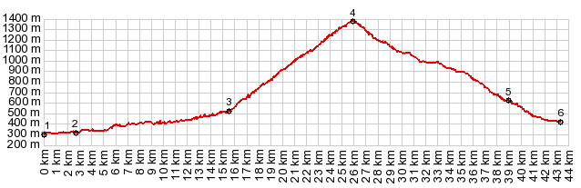
1.(00.0km,0300m) START-END NORTH:Asson
2.(02.7km,0320m)lower junction with D226 to L'Estelle Betharam
3.(15.8km,0540m)profile turns left up Col de Spandelles
4.(26.0km,1378m)TOP: Col de Spandelles
5.(39.0km,0610m)Gez
6.(43.3km,0320m)START-END SOUTH:bridge over La Gave de Pau, below Argeles-Gazost
|