| |
|
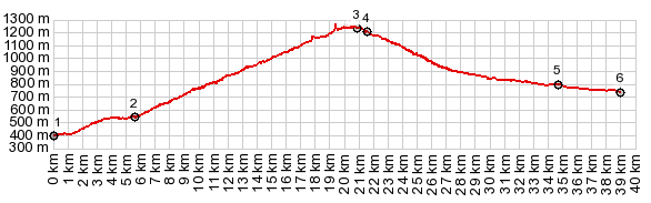
1.(00.0km,0400m) START-END EAST:turnoff to
Col de Rousset, on west end of Die
2.(05.3km,540m)Chamaloc
3.(20.9km,1260m)TOP:Col du Rousset, east entrance to
tunnel
4.(21.6km,1210m)turnoff on left to Font d'Urle and
Vasieux en Vercors
5.(34.7km,0800m)St Agnan en Vercors
6.(39.0km,0770m)START-END WEST:jct with road to les
Barrangques en Vercors on left
|