| |
|
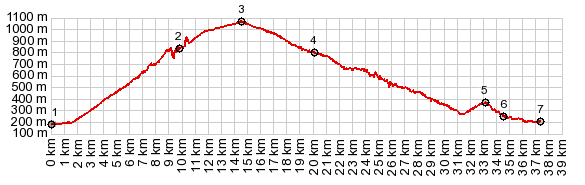
1.(00.0km,0200m) START-END NORTH: St
Gervais le Poret
2.(09.8km,0810m)tunnel entrance
3.(14.5km,1074m)TOP:Col de Romeyere
4.(20.0km,0810m)Rencurel
5.(33.3km,0370m)upper jct with road to Col de Toutes
Aures
6.(34.5km,0250m)lower jct with road to Col de Toutes
Aures
7.(37.4km,0190m) START-END SOUTH: low point north of
Pont en Royans
|