| |
|
|
|
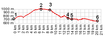
1.(00.0km,684m) START-END SOUTH: bridge across Canyon de l'Artuby
2.(06.4km,975m) TOP: D71 le Petit St-Maimes s(u)
3.(08.6km,978m) profile turns left towards Trigance
4.(13.1km,739m) upper turnoff to Trigance
5.(14.0km,725m) profile turns left onto D955 towards Castellane
6.(20.1km,645m) START-END NORTH: jct D955 - D952, south west of Castellane
|
|