| |
|
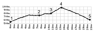
1.(550m,00.0km)START-END SOUTH ALT: jct D20-D902, south of
Mijouet
2.(740m,07.5km)START-END SOUTH: Boëge
3.(800m,10.5km)Villard
4.(963m,13.2km)TOP: Col Du Perret
5.(600m,20.5km)START-END NORTH: jct with D907, south of
Viuz-En-Sallaz