| |
|
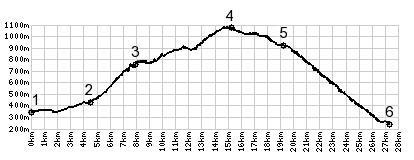
1.(350m,00.0km)START-END NORTH: jct D590A - Rue du Fort,
north of Barraux
2.(450m,04.6km)profile stays right on D282
3.(750m,07.9km)jct with road, traversing along Chartreuse
from north
4.(1060m,14.6km)TOP: Col de Marcieu
5.(910m,18.6km)profile turns downhill onto D30, south of
St Bernard
6.(250m,26.5km)START-END SOUTH: jct D30D-D1090, north of
La Terrasse