| |
|
|
|
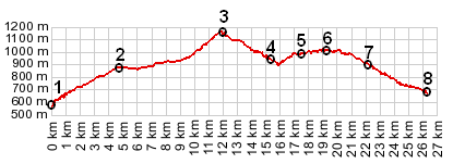
1.(00.0km,568m) START-END WEST: D26 bridge over Drac
2.(04.7km,874m) La Mure
3.(11.9km,1153m) TOP: Col de Malissol
4.(15.2km,950m) START-END EAST: profile turns right, down
5.(17.4km,970m) la Everras
6.(19.2km,1002m) Orris en Ratier
7.(22.1km,902m) le Haut Sievoz
8.(26.3km,960m) START-END EAST ALT: jct D526 - road from Sievoz, north east of Malbuisson
|
|