| |
|
|
|
This profile is difficult to get right, due to a few small steep hills at the summit. These ups and downs are steeper than they appear, and are smoothed away as noise by many smoothing algorithms, including the one used here.
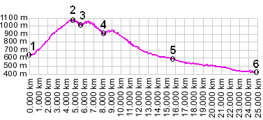
01.(00.0km,680m) START-END EAST: south end of Paularo
02.(04.8km,1075m) TOP: point of highest elevation
03.(05.6km,1020m) intermediate low point
04.(06.3km,1060m) intermediate high point
05.(15.7km,580m) START-END WEST ALTERNATE: south end of Paluzza, route continues downvalley.
06.(25.0km,420m) START-END WEST: Cedarchis
|
|