| |
|
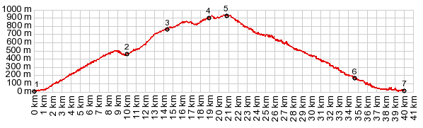
1.(00.0km,020m)START-END WEST:A7001 leaves from the coast
2.(10.0km,460m)shoulder summit point in Olas - jct with MA3110
3.(14.4km,760m)route turns off to the left, shortly before Puerto de la Bolina
4.(19.0km,900m)profile turns left onto A7000. Venta la Nades is to the right
5.(20.9km,920m)TOP: Puerto de Leon
6.(34.8km,170m)route crosses A7, before entering Malaga
7.(40.0km,020m)START-END EAST: Pasero Maritimo, Malaga
|