| |
|
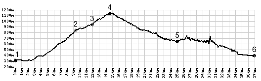
1.(300m,00.0km) START-END
NORTH: jct D5-D9, south of La Ravoire and Chambery
2.(830m,09.3km)jct with D912, a direct approach from
Chanmbery
3.(940m,11.8km)jct with D912e, another approach from west
4.(1134m,14.4km)TOP: Col Du Granier
5.(650m,24.6km)St Pierre D'Entremont, and jct with D912 on
left to Col du Granier
6.(400m,36.1km) START-END WEST: les Echelles