| |
|
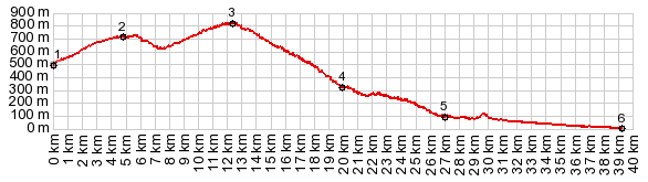
1.(00.0km,500m)START-END NORTH: Rio Durcal crossing, just east of Restabal
2.(04.8km,710m)jct with other approach, just above Pinos de Valle
3.(12.5km,830m)TOP: point of highest elevation
4.(20.0km,330m)profile turns hard right, before reaching Guajar-Fagaruit
5.(27.1km,100m)profile continues right on wider road N323A
6.(39.3km,020m)START-END SOUTH: Salobrena
|