| |
|
|
|
spikes in profile between kms 6 and 9 are due to tunnels that can be detoured
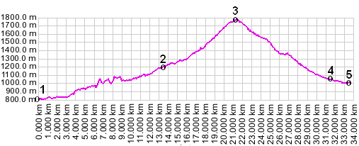
01.(00.0km,807m) START-END EAST: Floronzo, Pustertal. Route follows bike path along SS244
02.(13.3km,1187m) Sankt Vigil
03.(21.1km,1789m) TOP: Furkelpass
04.(31.4km,1049m) Valdaora
05.(33.5km,1011m) START-END WEST: jct SS49 - SP44, Pustertal
|
|