| |
|
|
|
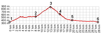
1.(00.0km,342m) START-END 1- Albertville, bridge over Arly
2.(08.0km,531m) profile turns left, up to Queige
3.(12.5km,870m) TOP: Col de la Forclaz
4.(15.6km,620m) left also descends into valley; right goes up onto ridge; profile stays straight
5.(19.4km,405m) profile turns left onto D1212 in Ugine
6.(27.7km,340m) START-END 2: same as point 1
|
|