| |
|
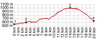
1.(00.0km,0550m) START-END WEST: low point on N260, a few km east of Ainsa, immediately after the Embalse Mediano
2.(03.0km,0600m)jct with sideroad from Alto Los Molinos on left, below Arro
3.(14.0km,1020m)TOP Collado/Puerto de Foradada
4.(19.9km,0650m) START-END EAST: bridge over Rio Esera, and jct with A139, south of Campo
|