| |
|
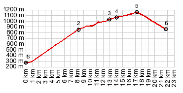
1.(00.0km,0270m)START-END SOUTH-1:St Jean
en Royans
2.(08.2km,0850m)lower turnoff point to Col l'Echarasson
on right; route continues straight
3.(13.0km,1011m)Col de la Machine
4.(14.1km,1060m)profile turns right up onto upper
turnoff to Col de l'Echarasson
5.(17.2km,1170m)TOP: Col de l'Echarasson
6.(21.7km,0850m)START-END SOUTH-2:same as point 2
|