| |
|
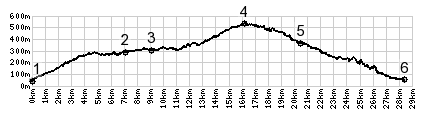
1.(50m,00.0km)START-END WEST:route starts climbing D719 or
Chemin de Cremat
2.(280m,07.0km)Route de Bellet/Boulvard de Madeleine joins
from right
3.(310m,08.9km)another Corniche joins from the Var Valley
on left
4.(530m,15.9km)TOP: D719 Aspremont(sh), a short distance
past Aspremont
5.(360m,20.2km)START-END EAST ALT: Tourette-Levens: jct
with road to Col Chateauneuf
6.(60m,28.0km)START-END EAST: M19 in Saint Andre De La
Roche