|
|
|
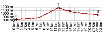
1.(00.0km,0816m)START-END WEST: low point
on D1075 at a small stream crossing
2.(00.7km,0830m)turnoff to Monastier de Percy
3.(11.8km,1167m)TOP: Col de la Croix Haute
4.(14.9km,1070m)turnoff to Col de la Grimone on left
5.(22.3km,0960m)START-END EAST: intermediate low point
on D1075
|