| |
|
|
|
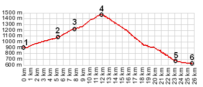
1.(00.0km,910m) START-END NORTH: jct D4 - D20, west of Grand Bonand
2.(05.3km,1064m) la Clusaz
3.(07.8km,1202m) profile turns left up D16
4.(11.8km,1477m) TOP: Col de la Croix de Fry
5.(23.2km,680m) profile turns left onto D12
6.(25.6km,624m) START-END SOUTH: Thones
|
|