| |
|
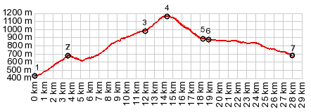
1.(00.0km,0440m) START-END EAST-1:bikepath
below Argeles-Gazost
2.(03.7km,0680m)profile branches onto D103 to right
3.(12.0km,0980m)profile turns onto D603 to right
4.(14.4km,1156m)TOP:Col des Borderes
5.(18.2km,0890m)Arrens-Massous
6.(18.9km,0880m)Aucun
7.(27.9km,0680m)START-END EAST-2: same as point 2
|