| |
|
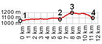
1.(00.0km,1046mm) START-END NORTH ALT: low spot on D2211, just east of Malamaire
2.(06.0km,1084m) START-END NORTH: profile turns left onto D80
3.(07.9km,1199m) TOP: Col Bas
4.(11.3km,1099m) START-END SOUTH: jct D79 - D81, south of Caille
|
|
1.(00.0km,1046mm) START-END NORTH ALT: low spot on D2211, just east of Malamaire 2.(06.0km,1084m) START-END NORTH: profile turns left onto D80 3.(07.9km,1199m) TOP: Col Bas 4.(11.3km,1099m) START-END SOUTH: jct D79 - D81, south of Caille
|