| |
|
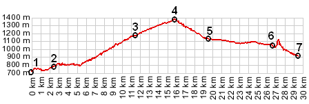
1.(00.0km,729m) START-END WEST: bridge over le Verdun, south end of Castellane
2.(02.5km,774m) route turns left from D4085 onto D102 and passes Chaudanne reservoir
3.(11.3km,1176m) Demandoix
4.(15.7km,1365m) TOP: Col de Saint Barnabe
5.(19.4km,1123m) START-END EAST: Soleihas
6.(26.6km,1052m) turnoff to Saint Auban, and Clue de St Auban shortly afterwards
7.(29.4km,903m) START-END WEST ALT: bridge over Esteron, below Clue de St Auban
|