| |
|
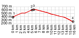
1.(00.0km,0390m)START-END WEST:bridge over
river La Desix at jct with road to Sournia
2.(05.0km,603m)Col des Ausines
3.(05.5km,620m)TOP: Col des Auzines, highest point for
these 2 approaches
4.(15.6km,0250m)START-END EAST:bridge over la Tet
revervoir, Vinca
|