| |
|
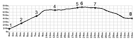
1.(80m,00.0km) START-END
EAST: leaving Riva Del Garda south, profile turns onto
Ponale shortly after this
2.(250m,03.2km)route turns right off Ponale road and
follows path to Valle Di Ledro
3.(470m,7.4km) Pre di Ledro
4.(660m,12.3km) Mezzolago
5.(730m,18.4km) Tiamo di Sotto
6.(753m,19.6km) TOP: highest point, in Tiamo di Sopra
7.(747m,23.1km) TOP: Passo dell'Ampolo
8.(410m,32.9km[800) START-END WEST: west of Storo; jct
with bike path along Fiume Chiese