| |
|
|
|
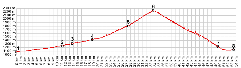
1.(00.0km,1085m) START-END SOUTH ALT: jct D908 - D62, north of Thorame Haute
2.(11.3km,1245m) START-END SOUTH: Colmars
3.(13.7km,1304m) Clignon Bas
4.(18.6km,1412m) turnoff towards Villard Bas, before reaching Allos
5.(27.4km,1998m) la Foux d'Allos, switchbacks begin shortly afterwards towards right
6.(33.6km,2247m) TOP: Col d'Allos
7.(49.4km,1226m) road crossing: left to Pra Loop; right connects to Col de la Cayolle approach
8.(53.2km,1133m) START-END NORTH: Barcelonnette, bridge over Ubaye
|